In some cold-weather environments, accurate up-to-date maps may not be
available and landmarks may be few or nonexistent. When the terrain is snow
covered, one piece of ground looks like the other. Whatever the circumstances,
you must be able to find your way — if not by map reading, by some other means
of navigation.
Only poor road nets may exist in some areas. These will be of little use in
cross-country navigation. If large-scale maps exist, they may be unreliable.
Long nights, falling or blowing snow, and fog limit visibility in winter.
Tracks and landmarks may be erased by heavy snowfall. Accurately identify
landmarks, through both ground and air observation, to prevent mistakes.
Conditions of daylight are different from those found in temperate regions
(moderate climate). In winter there are long nights and short days.
Magnetic disturbances may be common, thereby making compass readings
unreliable. Magnetic declinations may be extreme and can vary considerably at
close points.
Many small lakes, ponds, and creeks will be found that are not on the map.
The size and location of waterways may vary from year to year and from season to
season and cannot be relied on to pinpoint a position. Large lakes and rivers
can be used as important aids to navigation and movement.
When traveling from one point to another, it is necessary for you to know the
distance between them beforehand, then plot your journey accordingly.
In temperate zones, pacing is the simplest method of measuring distance. In
cold-weather areas, snow cover and the use of skis and snowshoes make pacing
challenging, and it must be practiced repeatedly.
USE OF FIELD WIRE
The best method for accurate ground measurement is for two men to use a piece
of salvage field wire 50 meters long. The lead man marches off in the desired
direction trailing the wire behind him. The second man signals by jerking the
wire when the first has gone 50 meters and then moves forward to the first man's
position. The first man marks the spot and continues forward for another 50
meters. This is repeated until the desired distance is reached.
ESTIMATION
If no other method of measurement is available, the length of time spent in
steady progress along a route may be used to estimate the distance traveled. The
accuracy of this method depends on how well you know your marching speed over
all types of terrain on foot, skis, or snowshoes.
9-6. DETERMINING DIRECTION
COMPASS
The use of the compass is the most common way to determine direction. The
magnetic field becomes weaker as you get nearer to the magnetic poles and can be
easily affected by other objects. It is important to make sure that the compass
is not affected by iron fragments in the ground, vehicles, or metal objects on
you.
THE SUN
There are two ways to determine direction by the sun:
-
At noon, in the northern hemisphere, shadows fall to the north of objects;
in the southern hemisphere, to the south of objects.
-
Estimate direction by using a watch and the sun. In northern latitudes the
hour hand is pointed toward the sun. An imaginary line halfway between the
hour hand and 1200 will point south. In southern latitudes the procedure is
different. Then point the 1200 toward the sun. An imaginary line halfway
between the hour hand and 1200 will point north.
NATURE
Nature will help in determining direction as in the following samples:
-
Single evergreen trees, growing away from other trees, will always be more
bushy on the south side.
-
The bark of birch and poplar trees is whitest on the south side and
darkest on the north.
-
You should know from which direction the prevailing winds blow. Trees will
be bent in the direction the wind is blowing or expected to blow.
THE STARS
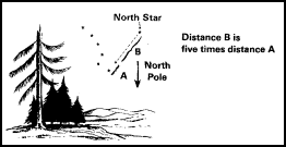
The North Star may be used to determine true north. This star can be easily
found by its position relative to the Big Dipper. In latitudes under 70 degrees
when traveling north, the North Star makes a good steering mark since its
bearing is usually only 1 degree from true north and is never more than 2 1/2
degrees away. In higher latitudes above 70 degrees, the North Star is too high
in the sky to indicate good direction.
A star near the horizon can be used with a bearing within 2 degrees of your
compass course. However, it will only be good for up to 30 minutes when you are
traveling north and only 15 minutes when traveling south. After these intervals,
select another star.

Figure 9-1. Determining direction using North Star.
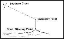
South of the equator, the constellation Southern Cross will help you locate
the general direction of south and any other direction. This group of four
bright stars is shaped like a cross that is tilted to one side. The two stars
forming the long axis, or stem, of the cross are called pointers. From the foot
of the cross, extend the stem five times its length to an imaginary point. This
point is in the general direction of south. From this point, look straight down
to the horizon and select a steering point.

Figure 9-2. Determining direction using Southern
Cross.
9-7. NAVIGATION BY DEAD RECKONING
Dead reckoning consists of plotting and recording a series of courses from a
known point, each measured for distance and direction. These courses lead from
the starting point to the destination. This lets the navigator determine his
position at any time, either by following his plot or by comparing his actual
position on the ground to his plotted course. All the details are previously
estimated and recorded.
EQUIPMENT FOR DEAD RECKONING
-
Maps are used for choosing the route and for plotting the route taken as
the march progresses.
-
Aerial photographs are usually used in addition to maps. They must be
vertical photos taken during the same season in which they are to be used.
-
The compass is used as the main direction-finding instrument.
-
The protractor is necessary in dead reckoning for plotting direction and
distance on the map, aerial photo, or chart. When using it, remember to
convert magnetic azimuth to grid azimuth.
-
A route card is used to outline the plan of the proposed march. Keeping a
log is mandatory. It is used to record the distance and direction.
-
The log is a written record of where the soldier has started, the distance
and direction traveled, and his position at any time in relation to the
planned route, destination, and starting point.
THE DRILL OF DEAD RECKONING
Know the starting point and destination and, having examined the map or
aerial photo for the best route, prepare a route card. This describes each leg
of the proposed route in terms of distance and direction. As the march
continues, keep a careful record of each bearing taken and the distance, and
record this in the log. There may be a change to the planned route because of
terrain or enemy action. Therefore, the necessary changes are made using the map
or aerial photo as a guide, and they are recorded in the log.
9-8. HINTS FOR THE NAVIGATOR
The navigator must keep the compass warm to speed up recording his position.
When no steering marks exist to the front, he should march on a back azimuth. A
steering mark may be a natural or man-made structure to the rear. If the
steering mark is not clear, he must keep an eye on it after taking an azimuth so
that it doesn't become lost. Never take magnetic azimuths in the area of metal
objects.
When visibility is poor, only close-in steering marks will be available.
Under these conditions try to pick up steering marks along the correct azimuth.
This can be done correctly only when the route to each steering mark follows a
straight line. Take compass checks often to ensure that the correct azimuth is
being followed. Set the compass for a night course. A steady unshifting wind
will also aid in keeping direction.
Depending on the area of the world, other signs can be used. For example, in
the barren and semibarren lands of eastern Canada, snowdrifts point to the
northwest and windblown trees to the southeast because of prevailing winds. In
Scandinavia, scratches on rocks and cliffs caused by the glacial period (ice
age) run northwest to southeast.


